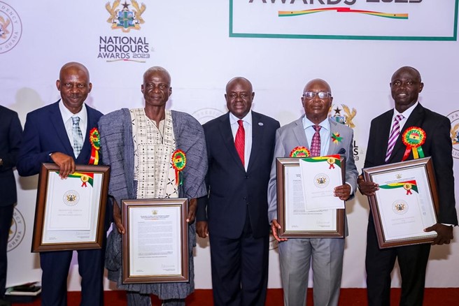
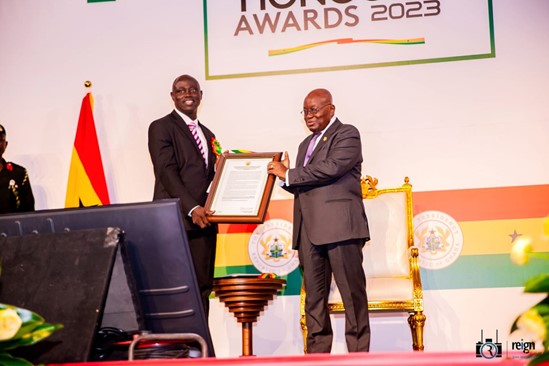
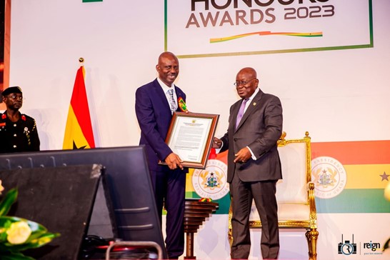
Rev. Prof. John Ayer and Dr. Cosmas Asante, Senior Members from Geomatic Engineering at the KNUST College of Engineering, received a Presidential Honor for their distinguished service, selfless sacrifices, and outstanding contributions to ensuring Ghana’s claim in the dispute concerning the delimitation of the Maritime Boundary between Ghana and Cote D’Ivoire on 14th March 2023 at the Accra Conference Center.
The Geomatic Engineering team, comprised of Prof. John Ayer and Dr. Cosmas Asante were part of the technical team that provided the necessary support to ensure Ghana’s claim was upheld by the International Tribunal For The Law Of The Sea (ITLOS) in 2017.
In 2006/2007, The Ministry of Lands and Natural Resources, under Prof. Dominic Fobi as Minister at the time, set up Ghana’s Maritime Space and Boundaries committee. The committee was to see to the extension of Ghana’s Continental Shelf Margin beyond two hundred nautical miles and up to 350 nautical miles for the submission of same to the United Nations as Ghana’s claim of Maritime space. This submission was to meet a timeline set by the United Nations Commission on the Law of the Sea (UNCLOS) by the 9th of May 2009.
This committee comprised two sub-committees; a technical Core Group and the Legal Group.
The technical group comprised experts from the GNPC, Geological Survey Department, Survey Department, and the Kwame Nkrumah University of Science and Technology KNUST.
The Mandate of the Technical Group included:
- Observations and Computations for establishing Ghana’s base points along the Coast.
- Collection of 3D Seismic under-ocean data to determine undersea depositions off the Ghana Coast.
- Studying all the various methodologies applicable for maritime and sea boundary delimitations.
- Use the most appropriate and applicable method to compute the following:
- The Maritime Boundary coordinates delimiting the Maritime boundary between Ghana and its neighbors.
- The Territorial Sea of Ghana
- The Exclusive Economic Zone boundary
- The Extended Continental Shelf of Ghana.
These objectives were to meet the critical requirement for a valid submission and also ensure that all Maritime boundaries with neighboring coastal states were delimited in accordance with the rules of procedure of the UN Commission on the Limits of the Continental Shelf (CLCS) or, at least, set aside under a bilateral agreement.
The team proposed the determined boundary to Cote D’Ivoire in 2008. It held several rounds of meetings with the Ivorian counterparts in Accra and Abidjan and the Land boundary terminus at New Town in the Western Region. Despite these efforts, the issue was not amicably resolved, as the Ivoirians were averred to set aside the proposed methodology to use Meridian 2 degrees and 52 minutes West as the delimiting line.
Not only did the technical team find this inappropriate, but they also pointed out the danger, as this would have resulted in all Ghana’s oil finds in the West being taken over by Cote D’Ivoire.
This compelled Ghana to resort to third-party adjudication, for which reason a legal firm, Matrix Chambers, based in the United Kingdom (UK), was engaged in 2012. The technical experts provided all the necessary inputs. They guided the legal team to take Cote D’Ivoire to arbitration at the International Tribunal for the Law of the Sea (ITLOS) in 2014.
It is interesting also to note that the arbitration Committee affirmed the Ghana Technical position on methodology for the boundary determination and hence up-held out the determined boundary.
The efforts and contributions to prosecuting the case ensured that the final boundary line was a 100 percent victory for Ghana and a return to the stability that had previously characterized the relations between Ghana and Cote D’Ivoire with respect to Maritime boundary and oil-related practices. It is also essential to indicate that in 2010, the team advised and coordinated the setting up of a National Boundary Commission, which resulted in the promulgation of the Ghana Boundary Commission Act.